|
Sequoia Farms Stomwater Management Retrofit Design
Fairfax County, Virginia
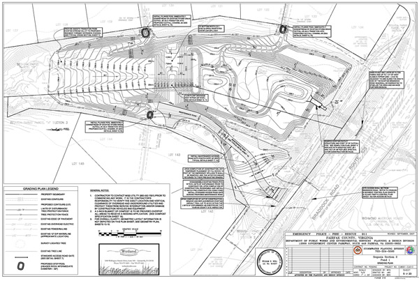
This project involved the retrofit of an existing stormwater management (SWM) facility that is deficient both in providing a sufficient BMP storage volume (due to ±25 years of sediment buildup) and in detaining the more frequent “channel forming” storm events (i.e., the 1-year and 2-year frequency storms) based on observed erosion activity immediately downstream of the SWM facility.
Using “Real Time” Differential GPS (Leica Geosystems), WSSI surveyors established a horizontal and vertical control network on the Sequoia Farms site and then converted the field data to Fairfax County’s required datum. After researching available land records and acquiring subdivision plats for perimeter lots, WSSI expanded the control network by conventional traverse and incorporated subdivision monumentation into the survey. WSSI performed a field run topographic survey using a grid detail sufficient to accurately depict a contour interval of 0.5’ and prepared drawings showing existing conditions and improvements, including storm structures and sewers. Point data (ASCII files), Digital Terrain Model (TIN), and finished contours were presented for design.
WSSI prepared project hydrology based on an SCS Curve Number Analysis for the applicable watershed (92.25 acres) to satisfy current hydrologic design criteria as required by the Fairfax County Public Facilities Manual. (The facility’s original design hydrology was based on the Rational Method.) WSSI then designed the SWM facility to provide:
- A “combined” BMP/1-year 24 hour storage volume, without causing any additional adverse impact above existing conditions for the higher storm events;
- A sediment forebay;
- Smooth transitions into the SWM facility from three (3) existing storm drain outfalls (sized for the 10 year storm event with velocities less than 4 feet per second);
- A micropool component and low-flow channel (maximum depth of 18”) upstream of the facility's outlet structure and its corresponding BMP orifice.
Design services also included the preparation of detailed planting plans and vegetation schedules for the impoundment area, as well as a traffic control plan for access from Braddock Road.
|